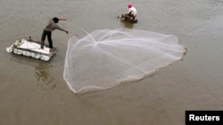
The basin of the Lower Mekong River, which runs from China, through Burma, Cambodia, Laos and Vietnam, and drains into the South China Sea, is home to over 60 million people. Some 85 percent of them rely directly on the river for their livelihoods, particularly those who are involved in irrigated agriculture and fishing.


This means that any unexpected occurrence that affects the flow of the Mekong River could spell disaster for the entire region.
That is why, on August 31st, USAID and NASA, in cooperation with the Asian Disaster Preparedness Center; the Deltares Institute of the Netherlands; Sweden’s Stockholm Environment Institute; and the Spatial Informatics Group of California; launched the “SERVIR-Mekong” project, which will use satellite imagery to monitor the region’s environment. The hope is that this technology will allow for more accurate prediction and management of floods, droughts and other natural disasters, allowing regional decision makers to improve agricultural risk management, manage land-use more sustainably, assess impacts of hydroelectric power facilities, and help governments and communities increase resilience to the negative effects of climate change.
So for example, satellite imaging will monitor weather patterns, water cycles and water availability, which may be heavily impacted by climate change, and by population growth. This will allow for better long-term planning, which should help improve regional food security and forest resource management.
On the other hand, a function called satellite remote sensing can monitor long-term changes in vegetated land cover caused by urbanization, de-forestation, and agricultural practices. This data could, for example, be used to determine whether current farming practices are producing optimal crop yields. Such information will allow agronomists, urban planners, natural resource managers, and forestry personnel to make informed decisions about crops, urban development and forest management, to name just a few.
"Under SERVIR-Mekong, we are tapping into the best available science and technology to help protect this region's vital ecosystems and the benefits they provide to society," said Beth Paige, director of USAID's Regional Development Mission for Asia. "Already, Asian scientists, NASA scientists and others are beginning to develop tools to build resilience and contribute to tackling some of the region's most pressing challenges."